These records are found in the online catalog of The Mariners’ Museum and Park in Newport News, Virginia. Uncurated search results are presented to give researchers and interested readers an idea of whether the museum’s archives contain information about this vessel and whether it may be worthwhile to visit the museum’s catalog search page for further investigation. Uncurated results may be inaccurate or incomplete.
Mariners Museum online catalog search, July 12, 2026. Search phrase: "Ruby". Catalog returned 51 records; this selection table includes 51 records fetched through catalog result pages.
Use these buttons to send uncurated search results to your own app or text document for further research. First, check the box for any row, or click "Select All" then uncheck any rows. Then click "Show Selections". You can then copy your selections from the text box and past them into your app.
Captain Jake W. Coleman, 0-422327, home, 2 Park Row, Savannah, Ga., 110 th Infantry, 28th Division. Embarked Oct 43, Boston Port of Embarkation. Fought in France and Belgium; also at Bastogne, although his Division was not there. He is shown with Pvt. Ruby J. Groseclose, A-321019, Saltville, Va., 1st WAC Company, HRPE. Photo taken at Pier 4, HRPE, Newport News, Va., for Historical purposes.
Shows a woman in profile smiling at a man. Behind them more soldiers can be seen. The 8 x 10 print is a mirror image of the 4 x 5 print.
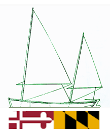
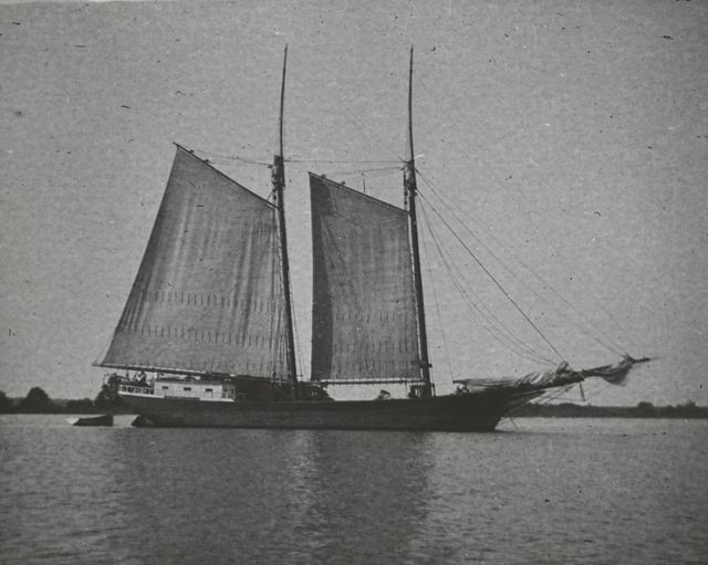
Shows a sloop moored in the water with some dwellings visible in the background. In the foreground a skiff or rowboat is moored between the sloop and shore. There is no caption for this negative.
NOTES: The naval battle of the Lizard took place on October 21, 1707 during the War of Spanish Succession near Lizard Point, Cornwall. It was fought by two French squadrons under Rene Duguay-Trouin and Claude de Forbin and an English convoy protected by a squadron under Commodore Richard Edwards. On October 20, 1707 a large fleet of 80 to 130 England merchant ships left Plymouth for Portugal with supplies for the war in Spain. The convoy was escorted by five ships: HMS Cumberland, HMS Devonshire, HMS Royal Oak, HMS Chester and HMS Ruby. The following day the convoy was spotted by two French squadrons of six ships each. The battle was a victory for the French who captured the Cumberland, Chester and Ruby. The Devonshire defended herself for several hours against seven French ships until she caught fire and exploded. The Royal Oal escaped with a few merchantmen into Kinsale. Its unclear exactly how many British merchant ships were captured ROUGH TRANSLATION: Naval Combat at the Dunes of England., English Vessels, of 200 Sails, A. The CUMBERLAND, of 82 Guns which was the Commander, B. The DEVONSHIRE, of 92 at the head, C. The ROYAL OAK, of 76 at the tail, D. le CHESTER, de 54, E. Le RUBY, de 56, F. Batimens de transport, Vassieaux Francois, G. Le LYS, de 74 Canons mount by du Gue-Trouin, H. L’ACHILLE, de 66 the Chevalier de Beau-harnois, I. La JASON, of 54 the Chevalier de Caurserac, L. La GLOIRE, of 40 Mr de la jaille (Squad of Mr Forbin), M. Le MAURE, of 50 Mr de la Moinerie-Miniac For., N. The BLAK-OWAL, from 54 the Chevalier de Tourouvre. for, O. L'AMAZONE, the Knight of Nesmond, P. SALISBURY, of 54 Mr Bart. (Sqn. Forbin), BB. The DEVONSHIRE was reduced to ashes and consumed in less than a quarter of an hour. All his crew perished amidst the flames and the waters, with the exception of three of his sailors. There were more than 1000 men in this vessel, which carried in addition to its crew more than 300 officers or soldiers as passengers. The CUMBERLAND Flag was brought to the Church of Notre Dame in Paris with those of the other English warships. HH. the ACHILLE ready to approach with all possible audacity the ROYAL-OAK was surprised by the fire which caught garpods full of powder; its bridges and forecastles were sunk and more than 100 men perished. He was happy enough to take off and extinguish this embrace; all the ships of the squadron of Mr. du Gue Troulin and that of Mr. le Comte de Forbin arrived in the harbor of Brest with the CUMBERLAND, the CHESTER and the RUBY. The CUMBERLAND was towed in triumph by the ships of General Forbin, the AMAZONE also seized several others which were taken by different Corsairs, who found themselves within range of taking advantage of the rout, and who made them enter into other Ports of France on October 21, 1707. In Paris at de Poilly rue S. Jacques a l'Esperance Memoire du Gue-Trouin, Amsterdam, Entrance to the Channel.
Left to right: T/5 Frank Bates, 10529 1/2 Ayres, Los Angeles, Calif; Mrs. Colleen Maness, 938 F St., Copeland Park, Va; Miss Virginia Flowers, Red Hill Village, Camp Patrick Henry, Va.; T/5 Marshall Bonar, 2211 McKenzie, Long Beach, Calif. Both men are veterans of the European Campaign with the Second Armored Division. Photo taken at CPH. (This caption belongs on L-14542)
Shows a woman at a cash register behind a bar, she has four customers before her. The caption for L-14541 reads: "Left to right: Sterling Hall, 1155 26th St., Newport News, Va.; T/5 Marshall Bonar, 2211 McKenzie, Long Beach, Calif; Miss Ruby Tatum, 638 Highland Court, Newport News, Va.; T/5 Frank Bates, 10529 1/2 Ayres, Los Angeles, Calif.; Miss Virginia Floers, Red Hill Village, Camp Patrick Henry, Va. Photo taken at CPH."
SHORT DESCRIPTION: Etched ruby glass wine glass with flag and inscription. NOTES: Notes made in the China File by Nola Hill - work done in the '40's or early 50's per Harold Sniffen, 12/7/81..Dominion Line
Photo shows, left to right: Pvt. Mary A. Meeker, A320042, home, Shickshinny, Pa.; Pvt. Katherina U. Rowe, A317071, home, Pennsylvania; & Pvt. Ruby Groseclose, A321019, home, Saltville, Va. WACs are sitting around fireplace in Day Room of 1st WAC Co. on Christmas Eve.
Christmas decorations–Virginia–Newport News.
Staged photo showing three WACs gathered around a fireplace that is decorated for Christmas.
Overall interior view of U.S. Army Finance Building on 34th St., Newport News, Va. Photo made for the Third Service Command.
Shows women working in an office setting. There are many filing cabinets and desks cluttered with paper, it looks like a busy work place. The 8x10 print contains additional information: View of the Commercial Accounts Section of the Finance Office, U.S. Army, HRPE. Left to right are: Mrs. Gladys Kelly, Newport News, Virginia; Mrs. Eva Stinson, Phoebus, Virginia; and Mrs. Ruby Dutton, Hampton, Virginia.
Shown on Pier 8, HRPE, Newport News, Va., after debarkation from the USS GENERAL A.E. ANDERSON, which had sailed from Manila, PI, 17 June 45, is T/Sgt. Cebron D. Brown, 14047106, Rt. 4, Gardo, Ala., Co. E, 35th Inf. Regt., 25th Division, who has sailed from NYPE 4 April 41, saw action in Honolulu at Pearl Harbor on 7 Dec. 41, went to Guadalcanal in Nov. 42, to La Vella, North Solomon Islands in Aug. 43 and to New Zealand in Dec. 43. He sailed from New Caledonia in Dec. 44 for Luzon, PI, where he arrived in Jan 45. He is 26 years old. He has not been wounded, but had malaria 7 times - one attack at Guadalcanal with fever of 106. T/Sgt. Brown is talking with Pvt. Ruby Groseclose, Saltville, Va., A-321019, 1st WAC Company, HRPE, assigned to the Troop Movement Division, HRPE. Photo taken for Historical purposes.
Photo shows scene at WAC Pajama Breakfast on Christmas morning held at Mess Hall of 1st WAC Company, HRPE, Newport News, Va. Left to right: Pvt. Thalia M. Burne, 320283, home, Redding, Pa., T/4 Ruth Ella Stanbaugh, 302701, home, York, Pa., Pvt. Anna Gallagher, home, Phila., Pa., Pvt. katherine Rowe, 317071, home, Shancockie, Pa., Pvt. Mary Anne Meeker, 320420, home, Shickshinerey, Pa., and Pvt. Ruby Groseclose, ASN 321019, home, Saltville, Va.
Dinners and dining–Virginia–Newport News.; Christmas–Virginia–Newport News.
Shows a crowded mess hall with tables full of seated women eating breakfast, several of them are in bathrobes or housecoats. The names given in the caption are not included in the index.
WAC is shown directing returning soldiers to train after their debarkation at Pier 6, HRPE, Newport News, Va. Photo taken for WAC recruiting publicity feature.
Railroad trains–Virginia–Newport News.
Shows men carrying their bags filing on to a train. There is a WAC standing at the doorway, she is smiling at them as they pass by.
Shown here are members of the third annual Women's Army Corps Staff Directors Conference. They are shown at Camp Patrick Henry where they lunched with the Third WAC Company. Photo taken at CPH. (Refer to Caption sheet for list of names.)
Group portrait of 27 WAC officers. They are outdoors in front of a building.
Photo shows, left to right: Mrs. Christine Bleecker, 8061 Reckord Drive, Lewis Park, Norfolk, Va.; Miss Ellen Toler, 2929 Welcome Road, Riverdale, Norfolk; Miss Ruby Price, 627 Graydon Ave., Norfolk, Va.,; Mr. Hillery Roland Lambert, 501 Dunmore St., Norfolk, Va., foreman of the Shop and Mrs. hazel E. Franklin, 2931 Broad Creek Rd., Norfolk, Va., clamping. Every truck before going overseas, must go through this processing line. Photo taken in Vehicle processing line at Warehouse #2k, NAB, HRPE, Norfolk, Va., for publicity and Historical purposes.
Military trucks–Virginia–Norfolk.
Shows five women working on a military truck to prepare it for shipping while a male supervisor looks on.
Shown here is Camp Lee's WAC basketball team which played at Camp Patrick Henry during the Third Service Command WAC basketball tournament. They are, left to right, kneeling: Pfc Dorothy Witcher, A907349, of Springfield, Oregon; Pvt Elizabeth Peabody, A110331, of Bennington, Vermont; Tec 5 Regina Demulling, A706289, of Stillwater, Minn.; Tec Ellen Slepicka, A703290, of Crete, Nebraska; and Sgt Lillian Savari, A915259, of Hailey, Idaho. Second row; Pvt Sarine VanDermark, A305554, of Philadelphia, Penn.; Tec 5 Harriett Garrity, A800861, of Humnoke, Arkansas; Tec 5 Jessie Stumph, A1000672, of Ahoskie, N.Car.; Tec 5 Ruby Rush, A810579, of Bonita, Louisiana; Pfc Gloria Davis, A221859, of Montclair, N. Jersey; and 1st Sgt Dolene Spencer, A909471, of Libby, Montana.
Pvt. Ruby Groseclose, A-321019, Saltville, Va., 1st WAC Co., HRPE, and Mr. William A. Rogers, Saltville, Va., civilian employee of Whse 19, HRPE are shown greeting Pfc. Raymond V. Rogers, Jr., 13121602, Saltville, Va., a member of the 805th Tank Destroyer Bn Reconnaissance Co, who has just debarked at Pier 8, HRPE, Newport News, Va., from the USS MARINE RAVEN. Pfc. Rogers, who received his training at Camp Hood, Texas, sailed from NYPE in Jun 43. Pvt. Groseclose and Pfc. Rogers had been friends since childhood. In background is an exhibit of insignia of Divisions which have debarked at HRPE. Photo taken for Historical purposes.
Signs and signboards–Virginia–Newport News.
Reunion of three individuals from the same small town in western Virginia. A soldier has his arm around the shoulder of a WAC and is hugging her close while he shakes the hand of an older man.
Lt. Justin J. Spence, O-1166186, Red Bank, New Jersey, 499th Armored Field Artillery, 14th Armored Division since 4 July 1945, is shown in Pier 8, HRPE, Newport News, Va., after debarking from the USS GENERAL J.C. BRECKINRIDGE with his brown dachshund "Dutch" as Pfc Ruby Groseclose, A-321019, Saltville, Va., 1st WAC Company, HRPE, feeds "Dutch" an American Red Cross doughnut. Lt. Spence's Shipment is (RE-7348-E). Photo taken for Historical purposes.
Dogs–Virginia–Newport News.
Shows a WAC feeding a donut to a small dog on a leash held by his owner.
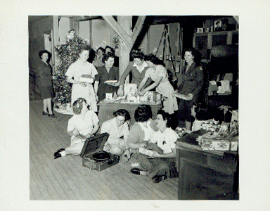
The observation of the Holiday Season at Camp Patrick Henry began with Open House at the 3rd WAC Company. Photo shows members of the company. Photo taken at CPH.
Shows a festive scene: in the background there is a group of WACs around a Christmas tree, in the middle ground some WACs are engaged in decorating a gingerbread house while others are holding presents, in the foreground another group of WACs is seated around a portable record player. The caption on the 8x10 print reads: "Members of the Third WAC Company, Camp Patrick Henry, Virginia, are shown in their Day Room receiving their Christmas gifts. In the front row, left to right are: Pfc. Ruby Stark, A-609568, Columbus, Wisconsin; Pfc. Marie Cocco, A-312042, Erie, Pennsylvania; Sgt. Catherine Brown, A-201855, New York, New York; Pfc. Bernice Robare, A-608325, Champion, Michigan; Pvt. Mary Urbas, A-313315, Couerdale, Pennsylvania; back row, left to right: Pfc. Elizabeth Greene, A-105442, Center Harbor, New Hampshire; Pfc. Ada Hosler, A-130182, Bridgeport, Connecticut; T/5 Martha Morris, A-704810, Duluth, Minnesota; Cpl.Corinne, Cooper, A-514384, Indianapolis, Indiana; Pfc. Grace Homeyer, A-704672, Minneapolis, Minnesota; Pfc. Thelma Maines, A-805158, Carthage, Texas; Pfc. Mary Schweikert, A-3201229, Pottsville, Pennsylvania; and Pfc. Annie J. Robertson, A-402724, Irondale, Alabama. The Third WAC Company held Open House, Thurday, 21 December 1944, and members invited friedns and relatives."
SANTA PAULA (STEAMSHIP: 1932) - GENERAL LE ROY ELTINGE (STEAMSHIP: 1945)
Mrs. Robert W. Winder, Newport News, Va., a member of Unit No. 3, American Red Cross Canteen Service, is shown serving grape juice to Sgt. Alvin D. Bartlett, 39616516, Missoula, Montana, 237th General Hospital Unit (Shipment R35515-WW). Sgt. Bartlett sailed overseas on the SANTA PAULA, 24 April 1945 from NYPE, as an Infantry replacement. Photo taken at Pier 8, HRPE, Newport News, Va., during the debarkation of the USS GENERAL LEROY ELTINGE for Historical purposes.
World War, 1939-1945–War work–Red Cross.
Shows a Red Cross worker with a pitcher and stack of paper cups pouring juice for a debarking soldier.
Mrs. Otto K. Meyer, 48 Brandon Road, Hilton Village, Va., (Center), is shown with other members of Unit No. 3, Red Cross Canteen Service, during debarkation of USS GENERAL LEROY ELTINGE. Mrs. Meyer wears a Purple Heart Ribbon, which her 17-year old son won post-humously during the Guadalcanal Campaign, 27 September 1942. Her husband is Captain of a Liberty Ship. Left to right: Elizabeth Frondt, Newport News, Va., who served soldiers of three wars: Spanish-American War, World War I and World War II; Belle Moskowitz, Newport News, Va.; Cassie Duke Winfield, Newport News, Va.; Mrs. Meyer; Mrs. Robert W. Winder, Newport News, Va.; Mrs. Lehman Z. Smith, Sr., Hampton, Va. and Mrs. Wade H. Hobbs, Newport News, Va. Photo taken for Historical purposes.
World War, 1939-1945–War work–Red Cross.
Shows seven women of the American Red Cross canteen service standing together on an HRPE pier.
E-10865 - Presentation of medals fro safe driving is made at Retreat, at Camp Headquarters, Camp Patrick Henry, to members of the 3rd WAC Company. Lt. Sarah I. Jencks, Chief of Women's staging Branch, is shown pinning medals on first row, while Lt. Marjorie B. Wightman, Assistant Public Relations Officer, is shown covering the second row. 11-16-44 Official Photograph, U. S. Army Signal Corps, HRPE, Newport News, Va.
Award presentations.; Award winners–Virginia–Newport News.; Military ceremonies, honors and salutes–Virginia–Newport News.
Shows several rows of WACs standing at attention at a retreat ceremony at Camp Patrick Henry. They are outdoors under trees.
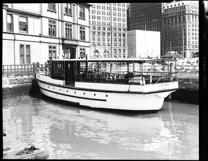
Harbors–Virginia–Pictorial works.; Marine terminals–Virginia–Norfolk–Photographs.; Piers–Virginia–Norfolk–Photographs.; Work boats–Virginia–Norfolk–Photographs.; Barges.; Tugboats.
A collection of 37 photographs depicting dock scenes and rail road car barges and tug boats in Norfolk harbor circa 1920. 5 Photographs by Norfolk photographer William Freeman depicting shipping fruit and vegetables from West Side N.Y.P & N.R.R. Pier Port Norfolk, Va. A collection of 22 photographs by William Rau of the Norfolk Terminals, Railroad tugboats Cape Charles, Crisfield, Delmar, Philadelphia, Parsley, Pocomoke, Norfolk, ,Portsmouth, Pennsylvania, Salisbury, and Harrisburg, PRR Barge No.153, railroad car barge No.4, Exmore Train Station, Exmore, Virginia, and the C& P.R.R. Locomotive #25.
Left to right: Sterling Hall, 1155 26th St., Newport News, Va.; T/5 Marshall Bonar, 2211 McKenzie, Long Beach, Calif; Miss Ruby Tatum, 638 Highland Court, Newport News, Va.; T/5 Frank Bates, 10529 1/2 Ayres, Los Angeles, Calif.; Miss Virginia Floers, Red Hill Village, Camp Patrick Henry, Va. Photo taken at CPH. (This caption belongs on L-14541)
Shows two men at the counter of a convenience store chatting with two women, one man is holding a carton of Lucky Strikes. The caption for L-14541 reads: "Left to right: T/5 Frank Bates, 10529 1/2 Ayres, Los Angeles, Calif; Mrs. Colleen Maness, 938 F St., Copeland Park, Va; Miss Virginia Flowers, Red Hill Village, Camp Patrick Henry, Va.; T/5 Marshall Bonar, 2211 McKenzie, Long Beach, Calif. Both men are veterans of the European Campaign with the Second Armored Division, Photo taken at CPH."
MONTE CRISTI - DOMINICAN REPUBLIC - Related Place; FRANCE - Publisher
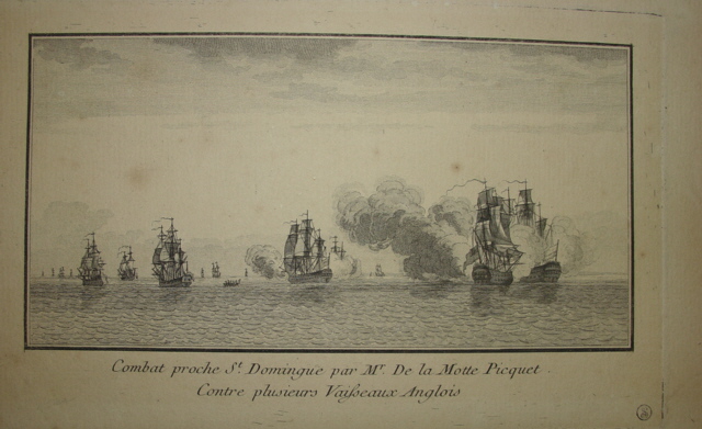
NOTES: Title roughly translates "Combat near St. Domingo by Mr. De la Motte Picquet against several English vessels". NOTES: Description of action from French source: In March of 1780, Admiral De la Motte Picquet left Martinique with four warships escorting a convoy of eighty merchant ships to Santo Domingo. On March 20, the French encountered three English ships under the command of Lord Cornwallis, and ordered them to be chased. Like the previous year when De la Motte Picquet managed to repel a strong English squadron with just three ships at the Battle of Martinique (December 18, 1779), he engaged the British ships alone for several hours before his squadron joined him. The combat continued all night, even though De la Motte Picquet was hit by a shell in the chest and remained unconscious for several hours. The next day, a dead calm prevented the two squadrons from maneuvering. The wind returned towards evening and the chase was renewed, but by this time three other English ships and several frigates had arrived as reinforcements. Outnumbered, De la Motte-Picquet fled before these new adversaries. The three ships that participated in the original engagement were severely damaged and did not follow him. De la Motte Picquet returned to Santo Domingo, where the convoy had preceded him. NOTES: The website morethannelson.com provides and overview of this action. The report was written by Richard Hiscocks and published on January 25, 2017: Action of Monte Cristi – 20-22 March 1780 Operating out of the Jamaican station where his badly damaged ship had fled following the Battle of Grenada the previous July, Captain Hon. William Cornwallis of the Lion 64 was cruising in the Windward Passage to the north of Monte Cristi, Haiti, in company with the Bristol 50, Acting-Captain Hon. Thomas Pakenham for the sickly Captain Toby Caulfield, and Janus 44, Captain Bonovier Glover, when on the morning of 20 March his ships fell in with a superior French squadron. This force, consisting of the L'Annibal 74, Le Diademe 74, Le Reflechi 64, L'Amphion 50, and Amphitrite 32 [another source says the 32 gun ship was La Diane], was under the flag of Rear-Admiral Jean Toussaint Guillaume La Motte-Picquet, and was escorting a convoy from Martinique to Cap Francois. Prudently despatching his charges to safety, the much-respected French admiral soon piled on sail to the north-west in pursuit of Cornwallis. In order to meet the enemy threat Cornwallis formed his three ships in line ahead, but he was soon overreached by the French flagship Annibal 74 when she came in range at about 5 p.m. A general action did not ensue however, for despite his superiority La Motte-Picquet showed no further inclination to close with the British that evening. Instead a long-range cannonade continued through to the early hours of the following morning. Come daylight a calming wind had drawn the Janus well away away from her consorts to leeward, so that that she became engaged with La Motte-Picquet's flagship, losing both her mizzen-top and fore-topgallant masts, but in turn inflicting more than superficial damage to the Annibal by using her manoeuvrability to hang off the Frenchman's quarter and stern. At some time in the morning Captain Glover, whose recent career had been plagued by a court martial called upon him by his officers, and who carried the stigma of not having exerted himself so well as was expected, died in his cot below of natural causes. The command devolved upon his first lieutenant, George Hopewell Stephens, an event which at the time was unknown to Cornwallis. Wishing to support the Janus, whose situation was becoming precarious with the approach of two of the Annibal's consorts, the boats of the Lion and Bristol were hove overboard and employed in towing the two heavier ships to the support of the frigate. After a three hour long-range engagement, one in which the Lion had to replenish the Bristol's stock of powder, the French hauled off to make good on their repairs, showing no interest in putting any of their ships at risk, but rather looking to the protection of their damaged flagship. Having effected repairs to his own squadron and somewhat unfairly castigating Lieutenant Stephens for not allowing Captain Glover the opportunity to restore his reputation by dying on deck, Cornwallis was rewarded for his obstinacy at dawn the next morning when the Ruby 64, Captain John Cowling, and two frigates, the Pomona 28, Captain Edmund Nugent, and Niger 32, Captain John Brown, came in sight. Their appearance was a hammer blow to La Motte-Picquet, who with a fresh breeze coming on from the east north-east had envisaged resuming the engagement with the inferior British squadron within the hour. At 6:30 a.m. the French admiral decided to abide by standing instructions to keep his ships in being, and he retreated before what he now considered might be a superior force. Signalling his squadron to make for Cap Francois and rejoin the convoy, La Motte-Picquet crowded on sail, and after a five hour chase Cornwallis threw over the pursuit, his squadron having sustained just twelve casualties in the three-day action. NOTES: LE 2103, LE 2104 and LE 2105 appear to be from the same publication. Another copy of LE 2103 was found at the Musee d'Aquitaine. The author was listed as anonymous and the creation date was given as 1806.
FRANCE - Artist; LIZARD POINT - CORNWALL - ENGLAND - Related Place
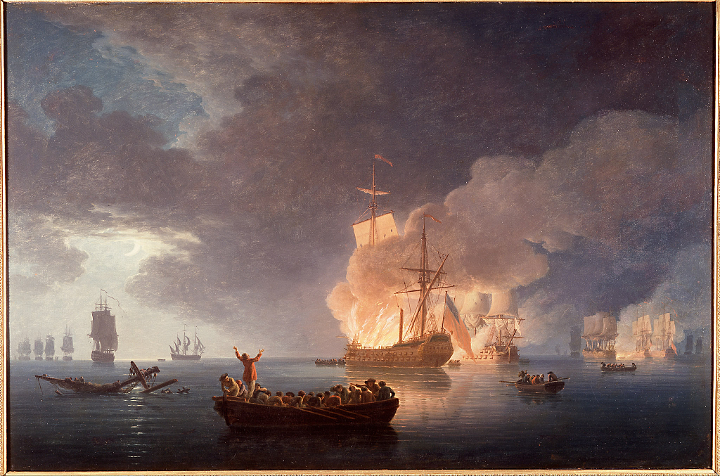
NOTES: [Marc Nucup, curator, March 11, 2008] The painting called Naval Combat by Claude-Joseph Vernet was acquired in 1992 as a representative piece by the artist. The subject of the canvas—a nighttime naval battle—is unknown and it seems that little is known about the subject beyond that it was the twelfth in a series of canvases Vernet painted for his patron Monsieur Girardot de Marigny. Michael Naxton suggests that the scene may portray the destruction of the HMS Dartmouth (50-guns) by the Spanish ship Glorioso (74-guns) in 1747 but I think the scene may actually depict the Battle at the Lizard on October 21, 1707 during the war of Spanish Succession. Here is my reasoning: In the Dartmouth/Glorioso action the Glorioso was inbound from the West Indies alone when she was attacked by two smaller English privateers and then two warships, part of a larger squadron. Unless the background scenes depict the chase of the Glorioso and an earlier stage of combat there seems to be too many combatant vessels involved. During that action the Dartmouth exploded at 3:30 in the afternoon but the scene appears to depict a night scene (moon is clearly visible). In addition, the ship that is engaged with the burning vessel (which would be the Glorioso according to Naxton’s theory) has a white jack. That flag is more apropos to a French vessel rather than a Spanish one. The action at the Battle at the Lizard featured a French attack by two squadrons (13 warships) on an escorted (5 ships) English convoy containing 80 to 130 ships. This would explain all of the ships—the English convoy possibly escorted by the HMS Royal Oak is in the background at the left. During this action the HMS Devonshire (80-guns) is destroyed by the Lys (or Lis) (74-guns) while the other convoy escorts (HMS Cumberland (80-guns), HMS Royal Oak (76-guns), and HMS Ruby (50-guns)) battle the main French fleet, while the HMS Chester (50-guns) is the warship to the middle left that seems to be rushing to join the battle (HMS Chester was covering the rear of the convoy). The commander of the Lys and half of the French fleet was Rene Duguay-Trouin, a wildly successful privateer and Admiral (he captured 16 warships and more than 300 merchant vessels from the English and Dutch). This is a more likely subject of a commissioned French painting (or for the series) than the ultimately unsuccessful battle with a Spanish warship that Naxton suggests is the subject of the scene. This being said, there are still some things that might indicate this painting does not depict the Battle at the Lizard. First, the ensign on the burning ship is not a clear depiction of Englands Red Ensign (although its pretty darn close). Second, the Devonshire burned from the stern forward while the vessel depicted is not (but that could be attributed to artistic license). Third, the Devonshire blew up after several hours leaving only three survivors while this scene shows many ship's boats in the foreground (again, this could be attributed to artistic license). Finally, I have found no indication that the battle took place at night. Despite these things, I still think the painting better matches the Battle at the Lizard than the attack on the Glorioso. [Research notes of Michael Naxton, February, 2000] The Vernet bought at Sotheby's Monaco, 1992. Since the work is dated 1786 when, unusually in the 18th century, England and France were not at war, my own view is that this scene is probably imaginary rather than actual. However, it would be immensely helpful to know whether the other works in the set from which this one comes (the notes, presumably taken from the auction catalogue entry, talk of this picture being the twelfth in a series painted for the artist's patron) depict real or imaginary scenes. Is there any way of finding this out? Certainly as far as this particular scene is concerned, only one incident in the whole century seems to fit the picture's content, namely the burning of H.M.S. Dartmouth by the Spanish Glorioso in 1747; a useful humiliation of the Royal Navy at the hands of France's ally Spain. [Alan Frazer, October, 1994] "Naval Combat", Claude-Joseph Vernet: This is believed to be the twelfth work of a series painted by Vernet for his patron, Monsieur Girardot de Marigny. It was acquired by the Museum as a work of art, representing an important artist, rather than as a historical document. Nothing is known of the engagement depicted, but if "real" it took place near the middle of the sixty years of Anglo-French warfare that ended after Waterloo. As might be expected of a French artist, it vividly pictures the destruction of an English two-decker in a raging inferno; explosion of her powder might be expected momentarily. With neither a date nor ship names, further historical research presents a major challenge TIME SPACE: 1714-1789.
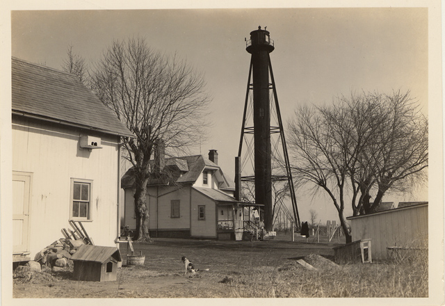
WRITTEN ON VERSO: FINNS POINT RANGE LIGHT, 4TH DISTRICT
CURATOR NOTES: Back yard view of light tower showing buildings, dog house and dog. Description: Soon after the 1638 landing of Finnish colonists near the present site of Wilmington, Delaware, small groups of settlers crossed over to the east bank of the Delaware River, where the land was thought to be more fertile, and established farms. One group selected land near the sweeping turn in the Delaware River, and this area remains known to this day as Finns Point. By an act of Congress in 1875, $55,000 was set apart for two pairs of range lights to help vessels transition from the Delaware Bay into the Delaware River. The Port Penn Range, located in Delaware, would guide traffic along the shipping channel from Ship John Shoal to Reedy Island, while the Finns Point Range would help vessels continue up the river, passing between Reedy Island and Baker Shoal. Lieutenant Colonel William F. Raynolds of the U.S. Army Corps of Engineers oversaw the construction of the front and rear range lights at Finns Point. The front light was located near the banks of the Delaware River and was displayed from a frame dwelling that was “one and one half stories high with shingle roof, double weather-boarded on outside and lathed and plastered inside. It rests on stone walls founded on wooden piles. The first story is divided into three rooms, with hall and stairways to the second floor and cellar, and shed over back door; porch and bay-window in front; the second story is divided similarly to the first; with step-ladder to lantern on the third floor; a gallery supported by brackets surrounds the lantern on front and sides.” The illuminating apparatus was a fourth-order range lens manufactured by Barbier & Fenestre in Paris, which focused the light from a fourth-order Funk Heap lamp with one wick. A weight, suspended from the lantern room, powered an eclipser that raised and lowered a cylindrical shade around the light to produce two seconds of light followed by one second of darkness. The keeper was required to wind the weight every six and a half hours to keep the eclipser functioning. Three acres of land, located roughly one and a half miles inland from the front light, were purchased from Joshua and Mary Dickinson on April 20, 1876 as the site for the rear range light. To provide a focal plane higher than that of the front light, the project plans called for a tall, wrought iron tower to be used for displaying the rear light. The Kellogg Bridge Company of Buffalo was contracted to manufacture the components of this wrought iron tower, which were then transported to Salem, New Jersey by railcar. From Salem, teams of mules pulled large wagons loaded with pieces of the iron tower to the construction site. The tower was described in the Description of Lighthouse Sites of the Fourth Lighthouse District as being “94 feet 8 and one half inches high from base to the focal plane. It is of wrought-iron, braced and supported by beams and tie-rods; the shell of the tower is of one quarter inch sheets of iron, riveted together, with the necessary openings for windows; it is 8 feet in diameter; and lined on the inside with vertical tongue-and-grooved boards; it encloses a cast-iron spiral stairway leading to lantern and watch-room. The posts supporting the tower are of 9-inch I beams, braced together with 5-inch I beams and rods from one and a half to one inch in diameter. The posts have an inclination of 1 horizontal to 6 vertical; they are held to masonry piers 6 feet deep by bolts, two at each post, attached to a wrought-iron plate under the piers. The tower is entered through a cast-iron vestibule one story in height.” The supporting posts have a hexagonal foot print, and the number of stairs to the top of the tower is 130: 119 steps in the spiral staircase and 11 steps up a ladder to the lantern room. Each evening, the keeper would climb the tower and light the lamp that stood behind a 24-inch fourth-order range lens also manufactured by Barbier & Fenestre. In addition to displaying the rear light for the Finns Point Range, the tower exhibited a second light in a different direction. Produced by a lens lantern panel and visible over a 30° arc, this light indicated the turning point for vessels transitioning from the New Castle Range to the Deepwater Point Range – two range lights located just up the river. A ruby-colored pane placed in front of this secondary light, made it appear red to mariners. A frame keeper’s dwelling was built just west of the tower, along with a wood-framed privy and an oil house. The first keeper of the Finns Point Rear Range Light was Edward [Thomas] Dickinson who started serving on December 8, 1876 even though the light was not lit until April 2, 1877. Over the next thirty years, Dickinson never received a raise; his salary was held constant at $500 per annum. Dickinson served until his death on December 21, 1907, and the following day his wife took over as acting keeper until Charles W. Norton transferred from the Finns Point Front Range on January 22, 1908. The final keeper of the rear range light was Milton Duffield, who served from 1916 to June 10, 1933, when the lights were discontinued. At the request of river pilots, the lights were re-established the following season, but automated beacons were installed so no new keepers were hired. The area surrounding the front range light was prone to flooding during storms, and by 1938 the site was often inundated at high tide. Rather than maintain a dated structure in these marshy conditions, a skeleton tower was built atop a concrete base just offshore from the former lighthouse in about three feet of water. Powered by batteries, the beacon on the new tower was activated on June 9, 1938, and the following year the dwelling, that had formerly housed the front light, was razed. In 1950, the Army Corps of Engineers dredged the Delaware River channel serviced by the Finns Point Range to a width of 180 feet and a depth of 40 feet. The range lights were deemed unnecessary as the Reedy Island Range to the south could now cover this wider section of the channel. Finns Point Range Lights were deactivated for good on March 22, 1950. The tall rear range tower and its accompanying dwelling sat abandoned for years and were often the target of vandalism. Graffiti adorned the bottom portion of the tower, and more than once, arson fires were set in the dwelling. In 1977, the old dwelling, now unsafe, was razed, but not everyone was ready to see the entire Finns Point station lost. Betty Husarik formed a “Save the Lighthouse Committee” in the 1970’s, and soon locals showed interest in moving the lighthouse to a nearby park for its centennial. The project faltered, but the group did succeed in placing the tower on the National Register of Historic Sites in 1978. In 1981, the committee, armed with the signatures of 1,100 people desirous that the tower be preserved, set off for Washington D.C. by bus to pay Congressman William Hughes a visit. This drive resulted in a contract for $33,600 being signed between the U.S. Fish and Wildlife Service, on whose land the tower now stood, and the K&K Painting Company of Baltimore to have the tower repaired, sandblasted, and painted. An open house was held at the tower on October 14, 1984 to honor the determined effort shown by the “Save the Lighthouse Committee” and others in restoring the tower. Today, there are informational signs displayed at the site, and the tower is opened occasionally for tours. The only other surviving structures from the Finns Point Range Lights is a brick oil house with a terra cotta shingle roof at the front light. The site of the front light is only accessible by boat, but one can drive down the road from the rear tower to Fort Mott State Park to view the area of the Delaware River formerly served by the Finns Point Range Lights. In 2004, a recreation of the keeper's dwelling was completed near the lighthouse to serve as an office for the Supawna Meadows Wildlife Refuge. References Guiding Lights of the Delaware River & Bay, Jim Gowdy and Kim Ruth, 1999.
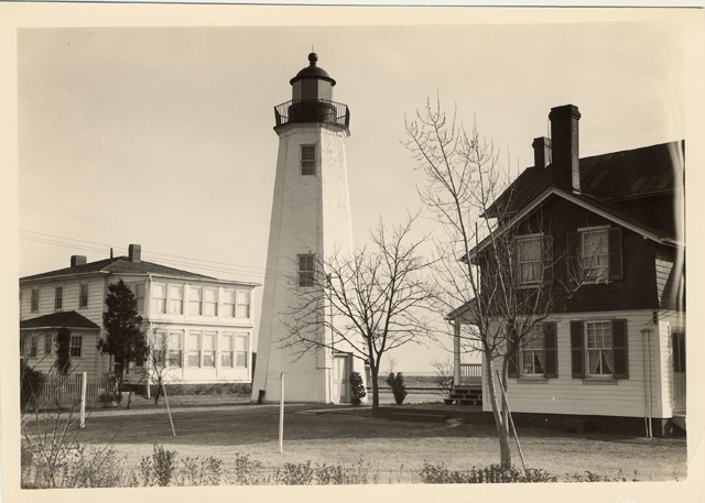
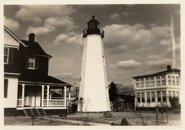
CURATOR NOTES: Close up view of old point comfort lighthouse with homes on either side. Description: Old Point Comfort Lighthouse marks the entrance to historic Hampton Roads, an important harbor situated at the mouths of the James, Nansemond and Elizabeth Rivers, and stands on ground which has seen many a fort constructed nearby to defend this import waterway. The tower’s present neighbor, the Civil-War era Fort Monroe, was preceded by colonial Fort George, which in turn was probably preceded by an even earlier fortification. A navigational beacon on Old Point Comfort was active as early as 1775 when John Dams, caretaker of the ruins at Fort George, was paid an annual supplement of 20 pounds to tend a light there. Some historians believe that Native Americans kept wood fires burning at the Point before that for the benefit of Spanish ships during the 16th century. With the establishment of the United States government and its ensuing lighthouse projects at places like Cape Henry, pressure mounted to build a permanent aid to navigation at Old Point Comfort. An early edition of the American Coast Pilot noted the 1798 law passed by the U.S. Congress that called for a light at Old Point Comfort, and proclaimed: “We wish, for the security of navigation, that the important work may soon be undertaken, for the safety of our mariners.” Between 1800 and 1801 Congress appropriated $5,000 for construction costs, and contracted the services of Elzy Burroughs to complete the octagonal stone structure. Burroughs completed most of the work on the lighthouse, which stands 54 feet high, during 1803. The tower possesses a spiral staircase composed of hand-cut stone, stacked strategically on top of each other. The stairs lead to a ladder that ascends to a trap door, beyond which is the lantern room. Eleven oil lanterns, which consumed 486 gallons of oil each year, were set in fourteen-inch reflectors to produce a light that could be seen from fourteen miles at sea. During the War of 1812, the lighthouse temporarily fell into British hands, when the Jack Tars and Royal Marines sailed into the Chesapeake. Frustrated in their efforts to seize the town of Norfolk, the invaders landed at Old Point Comfort and used the tower as an observation post. From there they went on to take and burn Hampton on June 25th, 1813, and then torch Washington D.C. a weeks later on August 14th. After the war, Old Point Comfort was vastly transformed by both the federal government and private investors. The government erected Forts Monroe and Calhoun, the former on shore and the latter on a man-made island called ‘Rip Raps’ situated in the middle of Hampton Roads. The clever Robert E. Lee, Lieutenant of Engineers, was transferred to Fort Monroe in 1831 and was instrumental during the next three years in helping complete construction on Fort Monroe, which is the largest stone fort ever built in the United States . Entrepreneurs built several resort hotels and otherwise made the area into a vacationer’s paradise for the leading lights of a young American society. In 1855, the lighthouse received a companion structure; Congress had appropriated $6,000 to build a fog bell tower for navigation in inclement weather. The bronze bell was forty inches around and three feet high, and its ringing could be heard up to three miles away. Soon thereafter a beacon light was added to the station to guide ships docking at Fort Monroe. While most east coast lighthouses were damaged, destroyed or at least put out of commission during the Civil War, the tower at Old Point Comfort remained undisturbed during the conflict as Fort Monroe remained under Union control throughout the war. An observer perched on the deck of the lighthouse would have seen an impressive procession of historic events during the conflict. President Lincoln once landed at the wharf to Fort Monroe; he had come to witness the Union troops take Norfolk. The legendary battle of the first ironclads, the USS Monitor and the CSS Virginia, occurred just offshore in Hampton Roads. Finally at the end of the war Confederate President Jefferson Davis was imprisoned in an artillery room behind the light station. After the War Between the States, the lighthouse was in danger of being closed; an 1869 report contended that it no longer played a vital role for navigation. Evidently a number of festive establishments were putting out candlepower that dwarfed the little light. Among these were the Hygeia Hotel, the Sherwood Inn, the Chamberlain Hotel and the Adams Express Company. Given the increasing sophistication of the area, it is likely that the historic and aesthetic value of the light helped save it. Instead of being decommissioned, the lighthouse grounds were vastly improved upon. In 1891, a new keeper’s house, built just south of the tower, replaced the original 1823 dwelling, and various buildings such as a stable, new oil house and iron railings were added as well. The station was hooked up to a modern sewer line in 1901, and the resulting dug-up grounds were substantially re-landscaped. Fifty cart loads of topsoil were spread on the premises and sixty-three varieties of plants and grasses were planted. Improvements to the station continued to be made in the new century. The oil fuel lanterns were replaced by electric power, and the beam increased in intensity to 3,300 candlepower. With advances in aeronautics the station was designated as an aerial landmark. One of the buildings’ roofs was painted in a distinctive pattern, part of a chain enabling pilots to find their way from Washington D.C. to Norfolk. In 1936, an experimental apparatus was added to control the fog signal. A beam of light was shot every two minutes from nearby Fort Wool, onto a photoelectric cell at Old Point Comfort. If the beam failed to arrive, that meant it had been impeded by rain, fog or snow, and the fog signal was activated. The problem of competing coastal lights from hotels and attractions was tackled in an innovative manner in 1954. A Coast Guard officer in charge of the lighthouse attached five 250 watt bulbs on poles extending from the guardrails, so that they resembled spokes on a wheel. While this may have made it more noticeable, one writer in The Keeper’s Log lamented that “it made the light look like an amusement park ride...rather than a noble lighthouse.” Over the years the characteristic of the Old Point Comfort Lighthouse was altered several times. In 1905, the Lighthouse Board reported that “the light was again changed to a fixed red through the entire arc of visibility.” In the 1950s, the ruby-red glass was still in place in the lantern room, but the automated signal showed a mixture of red and white light. The white beam covered 132 degrees of the circle, while red occupied the rest. The pattern was arranged in such a way that if a ship saw red, the crew knew it was on a “danger course.” Today the lighthouse tower is a freshly painted white, topped by a dull red, domed copper roof and a lightning rod. The structure has four large double-paned windows, with bright green doors, sashes and frames. The ‘eye-catching’ green was rumored to be a contractual error that would soon be corrected, but it has remained for years. A solid steel door guards the base of the lighthouse, alongside a plaque denoting it as a Virginia National Landmark. The keeper’s dwelling housed the families of two Coast Guardsmen until automation in 1973; presently it is the house of an Army Major. The house was described in an inventory of the station produced by the Army as stylistically eclectic, exhibiting “influences from the Shingle Style of the 1870's, the Stick Style of the 1870's, a touch of Queen Anne, and a soupçon of Eastlake.” The Old Point Comfort Lighthouse has been privy to events of great military importance, since those it overlooked during the Civil War. Teddy Roosevelt’s ‘Great White Fleet’ set sail from Hampton Roads in 1907 for its cruise around the world. On November 14, 1910, the first launching of a plane from a warship took place on the deck of the USS Birmingham in Hampton Roads. Today, the historic lighthouse still watches over the busy waterway frequented by sailboats and aircraft carriers. References “Two Points of Comfort,” Trask, The Keeper’s Log, Fall 1997. Lighthouses of Virginia, Jerry Zaccaria, 1998.
WRITTEN ON VERSO: OLD POINT COMFORT, VA., BUILT 1802, 40 FT. HIGH
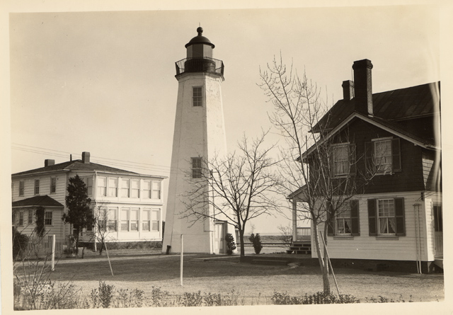
CURATOR NOTES: Close up view of Old Point Comfort lighthouse with homes on either side. Description: Old Point Comfort Lighthouse marks the entrance to historic Hampton Roads, an important harbor situated at the mouths of the James, Nansemond and Elizabeth Rivers, and stands on ground which has seen many a fort constructed nearby to defend this import waterway. The tower’s present neighbor, the Civil-War era Fort Monroe, was preceded by colonial Fort George, which in turn was probably preceded by an even earlier fortification. A navigational beacon on Old Point Comfort was active as early as 1775 when John Dams, caretaker of the ruins at Fort George, was paid an annual supplement of 20 pounds to tend a light there. Some historians believe that Native Americans kept wood fires burning at the Point before that for the benefit of Spanish ships during the 16th century. With the establishment of the United States government and its ensuing lighthouse projects at places like Cape Henry, pressure mounted to build a permanent aid to navigation at Old Point Comfort. An early edition of the American Coast Pilot noted the 1798 law passed by the U.S. Congress that called for a light at Old Point Comfort, and proclaimed: “We wish, for the security of navigation, that the important work may soon be undertaken, for the safety of our mariners.” Between 1800 and 1801 Congress appropriated $5,000 for construction costs, and contracted the services of Elzy Burroughs to complete the octagonal stone structure. Burroughs completed most of the work on the lighthouse, which stands 54 feet high, during 1803. The tower possesses a spiral staircase composed of hand-cut stone, stacked strategically on top of each other. The stairs lead to a ladder that ascends to a trap door, beyond which is the lantern room. Eleven oil lanterns, which consumed 486 gallons of oil each year, were set in fourteen-inch reflectors to produce a light that could be seen from fourteen miles at sea. During the War of 1812, the lighthouse temporarily fell into British hands, when the Jack Tars and Royal Marines sailed into the Chesapeake. Frustrated in their efforts to seize the town of Norfolk, the invaders landed at Old Point Comfort and used the tower as an observation post. From there they went on to take and burn Hampton on June 25th, 1813, and then torch Washington D.C. a weeks later on August 14th. After the war, Old Point Comfort was vastly transformed by both the federal government and private investors. The government erected Forts Monroe and Calhoun, the former on shore and the latter on a man-made island called ‘Rip Raps’ situated in the middle of Hampton Roads. The clever Robert E. Lee, Lieutenant of Engineers, was transferred to Fort Monroe in 1831 and was instrumental during the next three years in helping complete construction on Fort Monroe, which is the largest stone fort ever built in the United States . Entrepreneurs built several resort hotels and otherwise made the area into a vacationer’s paradise for the leading lights of a young American society. In 1855, the lighthouse received a companion structure; Congress had appropriated $6,000 to build a fog bell tower for navigation in inclement weather. The bronze bell was forty inches around and three feet high, and its ringing could be heard up to three miles away. Soon thereafter a beacon light was added to the station to guide ships docking at Fort Monroe. While most east coast lighthouses were damaged, destroyed or at least put out of commission during the Civil War, the tower at Old Point Comfort remained undisturbed during the conflict as Fort Monroe remained under Union control throughout the war. An observer perched on the deck of the lighthouse would have seen an impressive procession of historic events during the conflict. President Lincoln once landed at the wharf to Fort Monroe; he had come to witness the Union troops take Norfolk. The legendary battle of the first ironclads, the USS Monitor and the CSS Virginia, occurred just offshore in Hampton Roads. Finally at the end of the war Confederate President Jefferson Davis was imprisoned in an artillery room behind the light station. After the War Between the States, the lighthouse was in danger of being closed; an 1869 report contended that it no longer played a vital role for navigation. Evidently a number of festive establishments were putting out candlepower that dwarfed the little light. Among these were the Hygeia Hotel, the Sherwood Inn, the Chamberlain Hotel and the Adams Express Company. Given the increasing sophistication of the area, it is likely that the historic and aesthetic value of the light helped save it. Instead of being decommissioned, the lighthouse grounds were vastly improved upon. In 1891, a new keeper’s house, built just south of the tower, replaced the original 1823 dwelling, and various buildings such as a stable, new oil house and iron railings were added as well. The station was hooked up to a modern sewer line in 1901, and the resulting dug-up grounds were substantially re-landscaped. Fifty cart loads of topsoil were spread on the premises and sixty-three varieties of plants and grasses were planted. Improvements to the station continued to be made in the new century. The oil fuel lanterns were replaced by electric power, and the beam increased in intensity to 3,300 candlepower. With advances in aeronautics the station was designated as an aerial landmark. One of the buildings’ roofs was painted in a distinctive pattern, part of a chain enabling pilots to find their way from Washington D.C. to Norfolk. In 1936, an experimental apparatus was added to control the fog signal. A beam of light was shot every two minutes from nearby Fort Wool, onto a photoelectric cell at Old Point Comfort. If the beam failed to arrive, that meant it had been impeded by rain, fog or snow, and the fog signal was activated. The problem of competing coastal lights from hotels and attractions was tackled in an innovative manner in 1954. A Coast Guard officer in charge of the lighthouse attached five 250 watt bulbs on poles extending from the guardrails, so that they resembled spokes on a wheel. While this may have made it more noticeable, one writer in The Keeper’s Log lamented that “it made the light look like an amusement park ride...rather than a noble lighthouse.” Over the years the characteristic of the Old Point Comfort Lighthouse was altered several times. In 1905, the Lighthouse Board reported that “the light was again changed to a fixed red through the entire arc of visibility.” In the 1950s, the ruby-red glass was still in place in the lantern room, but the automated signal showed a mixture of red and white light. The white beam covered 132 degrees of the circle, while red occupied the rest. The pattern was arranged in such a way that if a ship saw red, the crew knew it was on a “danger course.” Today the lighthouse tower is a freshly painted white, topped by a dull red, domed copper roof and a lightning rod. The structure has four large double-paned windows, with bright green doors, sashes and frames. The ‘eye-catching’ green was rumored to be a contractual error that would soon be corrected, but it has remained for years. A solid steel door guards the base of the lighthouse, alongside a plaque denoting it as a Virginia National Landmark. The keeper’s dwelling housed the families of two Coast Guardsmen until automation in 1973; presently it is the house of an Army Major. The house was described in an inventory of the station produced by the Army as stylistically eclectic, exhibiting “influences from the Shingle Style of the 1870's, the Stick Style of the 1870's, a touch of Queen Anne, and a soupçon of Eastlake.” The Old Point Comfort Lighthouse has been privy to events of great military importance, since those it overlooked during the Civil War. Teddy Roosevelt’s ‘Great White Fleet’ set sail from Hampton Roads in 1907 for its cruise around the world. On November 14, 1910, the first launching of a plane from a warship took place on the deck of the USS Birmingham in Hampton Roads. Today, the historic lighthouse still watches over the busy waterway frequented by sailboats and aircraft carriers. References “Two Points of Comfort,” Trask, The Keeper’s Log, Fall 1997. Lighthouses of Virginia, Jerry Zaccaria, 1998.
WRITTEN ON VERSO: OLD POINT COMFORT, VA., BUILT 1802, 40 FT. HIGH
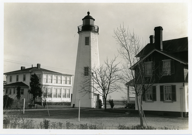
CURATOR NOTES: Close up view of old point comfort lighthouse with homes on either side. Description: Old Point Comfort Lighthouse marks the entrance to historic Hampton Roads, an important harbor situated at the mouths of the James, Nansemond and Elizabeth Rivers, and stands on ground which has seen many a fort constructed nearby to defend this import waterway. The tower’s present neighbor, the Civil-War era Fort Monroe, was preceded by colonial Fort George, which in turn was probably preceded by an even earlier fortification. A navigational beacon on Old Point Comfort was active as early as 1775 when John Dams, caretaker of the ruins at Fort George, was paid an annual supplement of 20 pounds to tend a light there. Some historians believe that Native Americans kept wood fires burning at the Point before that for the benefit of Spanish ships during the 16th century. With the establishment of the United States government and its ensuing lighthouse projects at places like Cape Henry, pressure mounted to build a permanent aid to navigation at Old Point Comfort. An early edition of the American Coast Pilot noted the 1798 law passed by the U.S. Congress that called for a light at Old Point Comfort, and proclaimed: “We wish, for the security of navigation, that the important work may soon be undertaken, for the safety of our mariners.” Between 1800 and 1801 Congress appropriated $5,000 for construction costs, and contracted the services of Elzy Burroughs to complete the octagonal stone structure. Burroughs completed most of the work on the lighthouse, which stands 54 feet high, during 1803. The tower possesses a spiral staircase composed of hand-cut stone, stacked strategically on top of each other. The stairs lead to a ladder that ascends to a trap door, beyond which is the lantern room. Eleven oil lanterns, which consumed 486 gallons of oil each year, were set in fourteen-inch reflectors to produce a light that could be seen from fourteen miles at sea. During the War of 1812, the lighthouse temporarily fell into British hands, when the Jack Tars and Royal Marines sailed into the Chesapeake. Frustrated in their efforts to seize the town of Norfolk, the invaders landed at Old Point Comfort and used the tower as an observation post. From there they went on to take and burn Hampton on June 25th, 1813, and then torch Washington D.C. a weeks later on August 14th. After the war, Old Point Comfort was vastly transformed by both the federal government and private investors. The government erected Forts Monroe and Calhoun, the former on shore and the latter on a man-made island called ‘Rip Raps’ situated in the middle of Hampton Roads. The clever Robert E. Lee, Lieutenant of Engineers, was transferred to Fort Monroe in 1831 and was instrumental during the next three years in helping complete construction on Fort Monroe, which is the largest stone fort ever built in the United States . Entrepreneurs built several resort hotels and otherwise made the area into a vacationer’s paradise for the leading lights of a young American society. In 1855, the lighthouse received a companion structure; Congress had appropriated $6,000 to build a fog bell tower for navigation in inclement weather. The bronze bell was forty inches around and three feet high, and its ringing could be heard up to three miles away. Soon thereafter a beacon light was added to the station to guide ships docking at Fort Monroe. While most east coast lighthouses were damaged, destroyed or at least put out of commission during the Civil War, the tower at Old Point Comfort remained undisturbed during the conflict as Fort Monroe remained under Union control throughout the war. An observer perched on the deck of the lighthouse would have seen an impressive procession of historic events during the conflict. President Lincoln once landed at the wharf to Fort Monroe; he had come to witness the Union troops take Norfolk. The legendary battle of the first ironclads, the USS Monitor and the CSS Virginia, occurred just offshore in Hampton Roads. Finally at the end of the war Confederate President Jefferson Davis was imprisoned in an artillery room behind the light station. After the War Between the States, the lighthouse was in danger of being closed; an 1869 report contended that it no longer played a vital role for navigation. Evidently a number of festive establishments were putting out candlepower that dwarfed the little light. Among these were the Hygeia Hotel, the Sherwood Inn, the Chamberlain Hotel and the Adams Express Company. Given the increasing sophistication of the area, it is likely that the historic and aesthetic value of the light helped save it. Instead of being decommissioned, the lighthouse grounds were vastly improved upon. In 1891, a new keeper’s house, built just south of the tower, replaced the original 1823 dwelling, and various buildings such as a stable, new oil house and iron railings were added as well. The station was hooked up to a modern sewer line in 1901, and the resulting dug-up grounds were substantially re-landscaped. Fifty cart loads of topsoil were spread on the premises and sixty-three varieties of plants and grasses were planted. Improvements to the station continued to be made in the new century. The oil fuel lanterns were replaced by electric power, and the beam increased in intensity to 3,300 candlepower. With advances in aeronautics the station was designated as an aerial landmark. One of the buildings’ roofs was painted in a distinctive pattern, part of a chain enabling pilots to find their way from Washington D.C. to Norfolk. In 1936, an experimental apparatus was added to control the fog signal. A beam of light was shot every two minutes from nearby Fort Wool, onto a photoelectric cell at Old Point Comfort. If the beam failed to arrive, that meant it had been impeded by rain, fog or snow, and the fog signal was activated. The problem of competing coastal lights from hotels and attractions was tackled in an innovative manner in 1954. A Coast Guard officer in charge of the lighthouse attached five 250 watt bulbs on poles extending from the guardrails, so that they resembled spokes on a wheel. While this may have made it more noticeable, one writer in The Keeper’s Log lamented that “it made the light look like an amusement park ride...rather than a noble lighthouse.” Over the years the characteristic of the Old Point Comfort Lighthouse was altered several times. In 1905, the Lighthouse Board reported that “the light was again changed to a fixed red through the entire arc of visibility.” In the 1950s, the ruby-red glass was still in place in the lantern room, but the automated signal showed a mixture of red and white light. The white beam covered 132 degrees of the circle, while red occupied the rest. The pattern was arranged in such a way that if a ship saw red, the crew knew it was on a “danger course.” Today the lighthouse tower is a freshly painted white, topped by a dull red, domed copper roof and a lightning rod. The structure has four large double-paned windows, with bright green doors, sashes and frames. The ‘eye-catching’ green was rumored to be a contractual error that would soon be corrected, but it has remained for years. A solid steel door guards the base of the lighthouse, alongside a plaque denoting it as a Virginia National Landmark. The keeper’s dwelling housed the families of two Coast Guardsmen until automation in 1973; presently it is the house of an Army Major. The house was described in an inventory of the station produced by the Army as stylistically eclectic, exhibiting “influences from the Shingle Style of the 1870's, the Stick Style of the 1870's, a touch of Queen Anne, and a soupçon of Eastlake.” The Old Point Comfort Lighthouse has been privy to events of great military importance, since those it overlooked during the Civil War. Teddy Roosevelt’s ‘Great White Fleet’ set sail from Hampton Roads in 1907 for its cruise around the world. On November 14, 1910, the first launching of a plane from a warship took place on the deck of the USS Birmingham in Hampton Roads. Today, the historic lighthouse still watches over the busy waterway frequented by sailboats and aircraft carriers. References “Two Points of Comfort,” Trask, The Keeper’s Log, Fall 1997. Lighthouses of Virginia, Jerry Zaccaria, 1998.
WRITTEN ON VERSO: OLD POINT COMFORT, VA., BUILT 1802, 40 FT. HIGH
CURATOR NOTES: Close up view of Old Point Comfort lighthouse with homes on either side. Description: Old Point Comfort Lighthouse marks the entrance to historic Hampton Roads, an important harbor situated at the mouths of the James, Nansemond and Elizabeth Rivers, and stands on ground which has seen many a fort constructed nearby to defend this import waterway. The tower’s present neighbor, the Civil-War era Fort Monroe, was preceded by colonial Fort George, which in turn was probably preceded by an even earlier fortification. A navigational beacon on Old Point Comfort was active as early as 1775 when John Dams, caretaker of the ruins at Fort George, was paid an annual supplement of 20 pounds to tend a light there. Some historians believe that Native Americans kept wood fires burning at the Point before that for the benefit of Spanish ships during the 16th century. With the establishment of the United States government and its ensuing lighthouse projects at places like Cape Henry, pressure mounted to build a permanent aid to navigation at Old Point Comfort. An early edition of the American Coast Pilot noted the 1798 law passed by the U.S. Congress that called for a light at Old Point Comfort, and proclaimed: “We wish, for the security of navigation, that the important work may soon be undertaken, for the safety of our mariners.” Between 1800 and 1801 Congress appropriated $5,000 for construction costs, and contracted the services of Elzy Burroughs to complete the octagonal stone structure. Burroughs completed most of the work on the lighthouse, which stands 54 feet high, during 1803. The tower possesses a spiral staircase composed of hand-cut stone, stacked strategically on top of each other. The stairs lead to a ladder that ascends to a trap door, beyond which is the lantern room. Eleven oil lanterns, which consumed 486 gallons of oil each year, were set in fourteen-inch reflectors to produce a light that could be seen from fourteen miles at sea. During the War of 1812, the lighthouse temporarily fell into British hands, when the Jack Tars and Royal Marines sailed into the Chesapeake. Frustrated in their efforts to seize the town of Norfolk, the invaders landed at Old Point Comfort and used the tower as an observation post. From there they went on to take and burn Hampton on June 25th, 1813, and then torch Washington D.C. a weeks later on August 14th. After the war, Old Point Comfort was vastly transformed by both the federal government and private investors. The government erected Forts Monroe and Calhoun, the former on shore and the latter on a man-made island called ‘Rip Raps’ situated in the middle of Hampton Roads. The clever Robert E. Lee, Lieutenant of Engineers, was transferred to Fort Monroe in 1831 and was instrumental during the next three years in helping complete construction on Fort Monroe, which is the largest stone fort ever built in the United States . Entrepreneurs built several resort hotels and otherwise made the area into a vacationer’s paradise for the leading lights of a young American society. In 1855, the lighthouse received a companion structure; Congress had appropriated $6,000 to build a fog bell tower for navigation in inclement weather. The bronze bell was forty inches around and three feet high, and its ringing could be heard up to three miles away. Soon thereafter a beacon light was added to the station to guide ships docking at Fort Monroe. While most east coast lighthouses were damaged, destroyed or at least put out of commission during the Civil War, the tower at Old Point Comfort remained undisturbed during the conflict as Fort Monroe remained under Union control throughout the war. An observer perched on the deck of the lighthouse would have seen an impressive procession of historic events during the conflict. President Lincoln once landed at the wharf to Fort Monroe; he had come to witness the Union troops take Norfolk. The legendary battle of the first ironclads, the USS Monitor and the CSS Virginia, occurred just offshore in Hampton Roads. Finally at the end of the war Confederate President Jefferson Davis was imprisoned in an artillery room behind the light station. After the War Between the States, the lighthouse was in danger of being closed; an 1869 report contended that it no longer played a vital role for navigation. Evidently a number of festive establishments were putting out candlepower that dwarfed the little light. Among these were the Hygeia Hotel, the Sherwood Inn, the Chamberlain Hotel and the Adams Express Company. Given the increasing sophistication of the area, it is likely that the historic and aesthetic value of the light helped save it. Instead of being decommissioned, the lighthouse grounds were vastly improved upon. In 1891, a new keeper’s house, built just south of the tower, replaced the original 1823 dwelling, and various buildings such as a stable, new oil house and iron railings were added as well. The station was hooked up to a modern sewer line in 1901, and the resulting dug-up grounds were substantially re-landscaped. Fifty cart loads of topsoil were spread on the premises and sixty-three varieties of plants and grasses were planted. Improvements to the station continued to be made in the new century. The oil fuel lanterns were replaced by electric power, and the beam increased in intensity to 3,300 candlepower. With advances in aeronautics the station was designated as an aerial landmark. One of the buildings’ roofs was painted in a distinctive pattern, part of a chain enabling pilots to find their way from Washington D.C. to Norfolk. In 1936, an experimental apparatus was added to control the fog signal. A beam of light was shot every two minutes from nearby Fort Wool, onto a photoelectric cell at Old Point Comfort. If the beam failed to arrive, that meant it had been impeded by rain, fog or snow, and the fog signal was activated. The problem of competing coastal lights from hotels and attractions was tackled in an innovative manner in 1954. A Coast Guard officer in charge of the lighthouse attached five 250 watt bulbs on poles extending from the guardrails, so that they resembled spokes on a wheel. While this may have made it more noticeable, one writer in The Keeper’s Log lamented that “it made the light look like an amusement park ride...rather than a noble lighthouse.” Over the years the characteristic of the Old Point Comfort Lighthouse was altered several times. In 1905, the Lighthouse Board reported that “the light was again changed to a fixed red through the entire arc of visibility.” In the 1950s, the ruby-red glass was still in place in the lantern room, but the automated signal showed a mixture of red and white light. The white beam covered 132 degrees of the circle, while red occupied the rest. The pattern was arranged in such a way that if a ship saw red, the crew knew it was on a “danger course.” Today the lighthouse tower is a freshly painted white, topped by a dull red, domed copper roof and a lightning rod. The structure has four large double-paned windows, with bright green doors, sashes and frames. The ‘eye-catching’ green was rumored to be a contractual error that would soon be corrected, but it has remained for years. A solid steel door guards the base of the lighthouse, alongside a plaque denoting it as a Virginia National Landmark. The keeper’s dwelling housed the families of two Coast Guardsmen until automation in 1973; presently it is the house of an Army Major. The house was described in an inventory of the station produced by the Army as stylistically eclectic, exhibiting “influences from the Shingle Style of the 1870's, the Stick Style of the 1870's, a touch of Queen Anne, and a soupçon of Eastlake.” The Old Point Comfort Lighthouse has been privy to events of great military importance, since those it overlooked during the Civil War. Teddy Roosevelt’s ‘Great White Fleet’ set sail from Hampton Roads in 1907 for its cruise around the world. On November 14, 1910, the first launching of a plane from a warship took place on the deck of the USS Birmingham in Hampton Roads. Today, the historic lighthouse still watches over the busy waterway frequented by sailboats and aircraft carriers. References “Two Points of Comfort,” Trask, The Keeper’s Log, Fall 1997. Lighthouses of Virginia, Jerry Zaccaria, 1998.
 MS0091-03-02-2664
 MS0091-03-01-86-032
 MS0003 - 001.1007-08395-Cornwall Ont CAN
 P0001.011-01-2624
 MS0003 - 001.2013-02790-Cornwall Ont CAN
 P0003-01 - L-12240
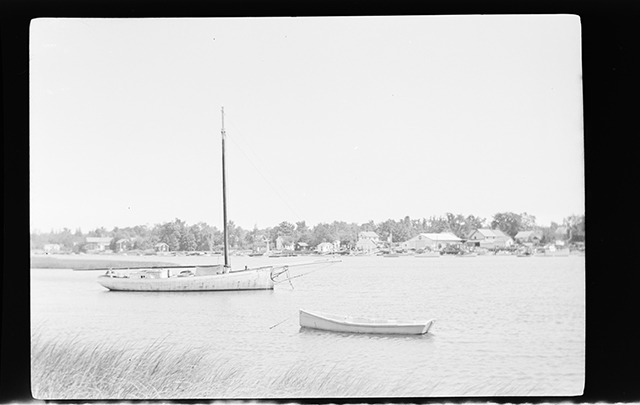 MS63-639 Sloop Ruby
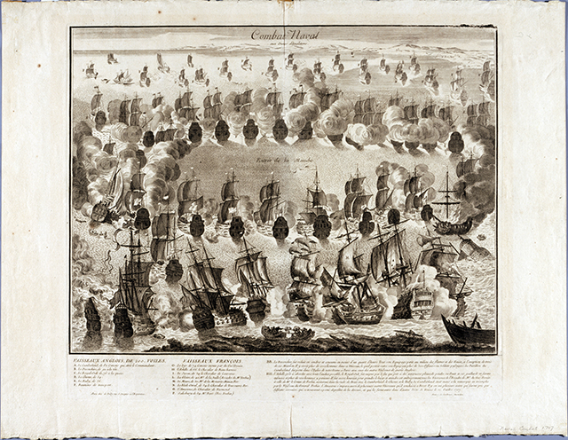 le716
 P0003-01 - L-14541
 P0003-01 - J-11475
 P0003-01 - H-12168
 P0003-01 - L-14851
 P0003-01 - J-11471
 P0003-01 - E-13083
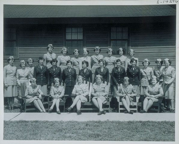 E-14296
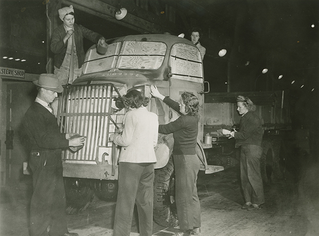 O-12217
 P0003-01 - K-13127
 P0003-01 - L-14981
 P0003-01 - L-15625
 J11402
 P0003-01 - L-15235
 P0003-01 - L-15238
 P0003-01 - H-12288
 MS0091-03-01-52-106
 P0003-01 - E-10865
 P0003-01 - E-10967
 P0003-01 - L-14542
 Full-size image
 1992.0017.0000011
 Full-size image
 Full-size image
 Full-size image
 Full-size image
 Full-size image